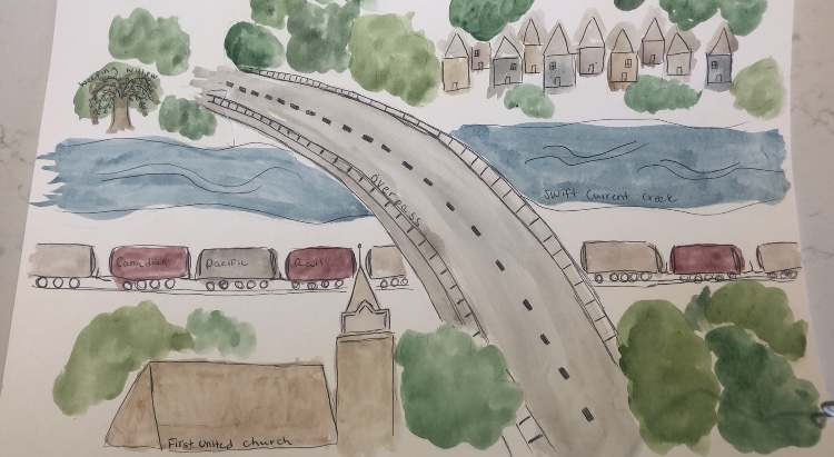
Above is a visual representation of a map that I created of my hometown Swift Current. The first thing that came to mind when I thought about mapping my hometown is the large bridge visible in the middle of the picture. This bridge is called the overpass, and it connects the north side of Swift Current to the south side. Both of my childhood homes, and the home I own now have all been on the south side so it has a special place in my heart. The south side is largely residential, with only one small grocery store, so it has always felt very secluded. Going over the overpass always reminds me that I am close to home.
Another thing I included in my representation is a church. Swift Current has always had an abundance of churches, there seemed to be one on every block while I was growing up. I would not consider myself religious now, but I attended church as a child and the church on every corner was a defining feature of that time.
The Swift Current Creek can also be seen in my image, although it doesn’t actually run under the overpass. This was a very important piece of my childhood as there were bike trails that run along the creek on the south side and I spent many hours riding my bike along these paths and catching crayfish in the creek. The creek is also where Swift Currents history begins and where it got its name. The creek carries a lot of Indigenous history, which you can read more about here. The creek was a camp for First Nations people for centuries, and may have been named after the same word the Cree used for the Saskatchewan River that flows nearby.
Another piece of Swift Current’s history, and also a memory of my childhood is the train tracks that run under the overpass. The trains passing through can be heard pretty much anywhere in Swift Current if it is quiet enough, and when I hear them at night it reminds me of sleepovers at my grandparents house. They lived far on the north side, but had no air conditioning, so in the summer we slept with the windows open and you could hear the trains softly throughout the night. The settlement of Swift Current was established after the Canadian Pacific Railway surveyed a line through the area, and that helped create the city as it stands today.
The very last piece of my visual representation is the weeping willow tree visible in the top left corner. This tree is not too common in the city, but we had one that grew in the front yard of my childhood home. Every year my parents talked about cutting the tree down, but they never did. They no longer live in that house but the tree is still standing!